Garmin Navionics+ and Garmin Navionics Vision+ Sale

Hookup1

GreatGrady Captain
Joined
Oct 16, 2007
Messages
3,035
Reaction score
855
Points
113
Age
70
Location
Cape May, NJ
Model
Islander
Garmin has the upgrades on sale for Bluechart g3 to the new Garmin Navionics+ and Vision+ charts.

Built-in U.S. & Coastal Canada Built-in Chart Updates Garmin Navionics+™ | BUS001L. $149.99 >>> $99.99 ---- check your unit to see if you can replace basemaps.
U.S. & Coastal Canada - Lakes, Rivers and Coastal Marine Charts Garmin Navionics+™ | NSUS001L. $199.99 >>> $149.99
U.S. East - Lakes, Rivers and Coastal Marine Charts Garmin Navionics Vision+™ | NVUS007 $249.99 >>> $149.99
U.S. South - Lakes, Rivers and Coastal Marine Charts Garmin Navionics Vision+™ | NVUS006R $249.99 >>> $149.99


Hookup1

GreatGrady Captain
Joined
Oct 16, 2007
Messages
3,035
Reaction score
855
Points
113
Age
70
Location
Cape May, NJ
Model
Islander
Garmin bought Navionics a few years back. The cartography was merged into g3 Bluechart. Garmin is now shipping Garmin Navionics+ charts on new units.

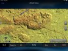
These charts look a little different and include 1 foot contours. The Garmin Navionics Vision+ also include shaded relief and satellite imagery. If you are bottom fishing the shaded relief charts are helpful for finding good bottom structure.

It's important to check to see if your Garmin unit will accept the new charts.
 

Ekea

Well-Known Member
Joined
Aug 11, 2020
Messages
634
Reaction score
214
Points
43
Age
39
Location
Mid Atlantic
Model
Chase
the shaded relief does look really nice...
 

Mwcarter41

Member
Joined
Sep 28, 2020
Messages
8
Reaction score
1
Points
3
Age
41
Model
Fisherman 236
Unless you have a fairly new unit, your unit won’t work with new navionics plus. My unit is a 2018 is not compatible
 

Ekea

Well-Known Member
Joined
Aug 11, 2020
Messages
634
Reaction score
214
Points
43
Age
39
Location
Mid Atlantic
Model
Chase
Unless you have a fairly new unit, your unit won’t work with new navionics plus. My unit is a 2018 is not compatible
is there a way to tell what year a unit was made?
 

Mwcarter41

Member
Joined
Sep 28, 2020
Messages
8
Reaction score
1
Points
3
Age
41
Model
Fisherman 236
is there a way to tell what year a unit was made?
I’m not sure if there’s a way to tell the year. I have a ECHOMAP Plus 94sv and wanted the relief shading. Unit was purchased in 2018. Unfortunately according to the compatibility charts, I’m unable to use the maps unless I upgrade my unit in which I hate to do on a fairly new unit. I ended up just downloading the navionics on my phone and will use that when I get close to where I’m going. $25 vs. new unit and cost of maps was a no brainer.
 

SkunkBoat

Well-Known Member
Joined
Oct 12, 2017
Messages
4,508
Reaction score
1,614
Points
113
Location
Manasquan Inlet NJ
Website
www.youtube.com
Model
Express 265
It’s not the year. It’s the model (which changes by year) and the resolution of the model. There is a compatibility list on the site. The relief shading is great for coastal NJ but not everywhere. Many US lakes also have relief shading. The new maps combine lake and coastal but now split by area. You have to read up before buying. I got US East and it was worth the upgrade for NJ fishing. I can use same map on 2 boats for freshwater and salt
I have a GPSMAP1242xsvTouch plus for salt boat and Echo74sv UHD on the tin boat. The Echo is much slower to zoom and pan. The GPSMAP is awesome.
 
Last edited:

Hookup1

GreatGrady Captain
Joined
Oct 16, 2007
Messages
3,035
Reaction score
855
Points
113
Age
70
Location
Cape May, NJ
Model
Islander
I bought the NVUS007R Vision+ East (includes NJ) for $149. Previously updated Built-in Base maps for $99 and bought VUS006R Vision+ South (FL and Gulf) for $200 from Hodges.
 

SkunkBoat

Well-Known Member
Joined
Oct 12, 2017
Messages
4,508
Reaction score
1,614
Points
113
Location
Manasquan Inlet NJ
Website
www.youtube.com
Model
Express 265
Relief shading on NJ reef sites is fantastic. I've been fishing some spots that I would not have tried before. Some I had numbers for, some I didn't. But when you can see it, it makes you confident to go there. Seabass fishing on Sea Girt reef has been great.
 

Hookup1

GreatGrady Captain
Joined
Oct 16, 2007
Messages
3,035
Reaction score
855
Points
113
Age
70
Location
Cape May, NJ
Model
Islander
Relief shading on NJ reef sites is fantastic. I've been fishing some spots that I would not have tried before. Some I had numbers for, some I didn't. But when you can see it, it makes you confident to go there. Seabass fishing on Sea Girt reef has been great.
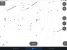
We had similar results in Florida Keys. Spots we fished for years with no idea why they produced. Also found we could improve our positioning to be closer to the structure. Here is a comparison of the standard fishing chart compared to the shaded relief on a favorite patch reef spot.

Shaded 2.jpeg Shaded.jpeg
 

Ekea

Well-Known Member
Joined
Aug 11, 2020
Messages
634
Reaction score
214
Points
43
Age
39
Location
Mid Atlantic
Model
Chase
darn, im pretty sure i also have the 94sv. maybe if i eventually go with a second display...
 

Recoil Rob

Well-Known Member
Joined
Mar 23, 2019
Messages
295
Reaction score
55
Points
28
Age
69
Location
CT Coast
Model
Sportsman
Help me out here.
I bought an 943xsv 2 years ago and dropped the extra $250 for the VUS004R New York BlueChart g3 Vision card.
This year I got a second unit which shipped with Navionics base maps and apparently can't use the old Vision card.
It came with Navionics base maps.
If I buy the upgrade card (I'm compatible) for the old unit will both units read the same?
The Garmin site says it's for a 1 year subscription? So it's $149 every year?

Will the VUS004R New York BlueChart g3 Vision card be obsolete?
 

Hookup1

GreatGrady Captain
Joined
Oct 16, 2007
Messages
3,035
Reaction score
855
Points
113
Age
70
Location
Cape May, NJ
Model
Islander
Rob -

These are on sale direct from Garmin. Not sure for how long. The subscription is for a year and includes all chart updates. After a year the charts still work but you don't get the navigational changes, etc. For most recreational guys you don't need to renew your subscription.

Built-in U.S. & Coastal Canada Built-in Chart Updates Garmin Navionics+™ | BUS001L. $149.99 >>> $99.99 ---- check your unit to see if you can replace basemaps.
U.S. East - Lakes, Rivers and Coastal Marine Charts Garmin Navionics Vision+™ | NVUS007 $249.99 >>> $149.99 -- covers GA to ME so CT is in there.

The VUS004R New York BlueChart g3 Vision card isn't of much use to you anymore. It is obsolete in that the units will use the newest charts (date/revision). It will still work in your old unit but not in the new one. My FL VUS010R is useless now as is yours. The new Vision is so much better though.

The NVUS007 Vision+ will install on both units (only buy 1 subscription). This includes the shaded relief charts which is really useful for fishing and really the only reason I bought Vision+ cards.

You could install the Garmin Navionics+™ | BUS001L too if you want. This will replace the g3 Basemaps in the one unit with Garmin Navionics+ subscription. This isn't necessary if you buy the NVUS007 Vision+ subscription.The Vision+ charts includes new basemaps for the region and will override the g3 basemaps because they are newer.

Before you do anything with charts setup Active Captain (only one card per system not unit). Use Active Captain to update the software on both units.

The difficult part is you have to download the subscription to a SD card and use Active Captain to install it. It gets confusing sometimesn even for me and I have spent a lot of time working with this stuff.

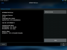
This is what your system information > software screen should look like except without the SOUTH supplemental maps.

IMG_0016.PNG
 
Last edited:
  • Like
Reactions: SkunkBoat

Recoil Rob

Well-Known Member
Joined
Mar 23, 2019
Messages
295
Reaction score
55
Points
28
Age
69
Location
CT Coast
Model
Sportsman
I have Active Captain setup and did use it to update the software on both units.

Both units will be connected using a network cable.

So it sounds like if buy the NVUS007 Vision update, it will upgrade the basemaps on my older unit and also upgrade both units to Vision+, is that right? I don't care much about updating the subscription every year, reefs and wrecks rarely move.

Hell, if that's it for $149 I'd do it and I could probably sell the old New York Bluechart g3 card on eBay...
 

Hookup1

GreatGrady Captain
Joined
Oct 16, 2007
Messages
3,035
Reaction score
855
Points
113
Age
70
Location
Cape May, NJ
Model
Islander
I have Active Captain setup and did use it to update the software on both units. Good. You will have to create the SD card from the download. Not sure if Active Captain can do it directly. Follow Garmin's instructions.

Both units will be connected using a network cable. Correct.

So it sounds like if buy the NVUS007 Vision update, it will upgrade the basemaps on my older unit (it will update the basemaps for the region which is all you need.) and also upgrade both units to Vision+, is that right? (Yes that is correct). I don't care much about updating the subscription every year, reefs and wrecks rarely move. (This is also true).

Hell, if that's it for $149 I'd do it and I could probably sell the old New York Bluechart g3 card on eBay...(Not sure but give it a try. Charts are licensed not sold. Garmin may not allow the license to be transferred.)
 
Last edited:

Recoil Rob

Well-Known Member
Joined
Mar 23, 2019
Messages
295
Reaction score
55
Points
28
Age
69
Location
CT Coast
Model
Sportsman
I spoke with Garmin, they suggested doing it through ActiveCaptain directly. They also confirmed the Vision+ will be on both units.

Thanks for your help..
 
Joined
Jan 17, 2023
Messages
22
Reaction score
4
Points
3
Age
55
Model
Seafarer
Garmin has the upgrades on sale for Bluechart g3 to the new Garmin Navionics+ and Vision+ charts.

Built-in U.S. & Coastal Canada Built-in Chart Updates Garmin Navionics+™ | BUS001L. $149.99 >>> $99.99 ---- check your unit to see if you can replace basemaps.
U.S. & Coastal Canada - Lakes, Rivers and Coastal Marine Charts Garmin Navionics+™ | NSUS001L. $199.99 >>> $149.99
U.S. East - Lakes, Rivers and Coastal Marine Charts Garmin Navionics Vision+™ | NVUS007 $249.99 >>> $149.99
U.S. South - Lakes, Rivers and Coastal Marine Charts Garmin Navionics Vision+™ | NVUS006R $249.99 >>> $149.99