Garmin Navionics Chart Renewals - caution

Hookup1

GreatGrady Captain
Joined
Oct 16, 2007
Messages
3,035
Reaction score
856
Points
113
Age
70
Location
Cape May, NJ
Model
Islander
My Garmin Navionics charts are coming up for subscription renewals. I used Active Captain App to renew my Garmin Navionics US & Canada Built in charts BUS001 and Apple completely screwed it up. The BUS001 charts list for $149.99, on sale new now for $99.99 and should renew for $74.99 (1/2 of list price). Apple charged $149.99 and won't cancel/refund the charge. Twice they refused the refund and won't allow me to challenge them a third time. I spoke to Garmin Customer Support and they are working with me to make good.

Login to Garmin.com - Account > Data Management > Manage Your Data > View Your Data > Subscriptions and Content to see your licenses and renew them here.

Garmin sometimes has a sale price on the charts too that is not passed on to the App Store in the Active Captain App as well. Go to Garmin.
 
Last edited:

SkunkBoat

Well-Known Member
Joined
Oct 12, 2017
Messages
4,509
Reaction score
1,614
Points
113
Location
Manasquan Inlet NJ
Website
www.youtube.com
Model
Express 265

My Vision+ renewed automatically. I'm not going to update the built-in chart

Your Plan Details​

Coverage area: Garmin Navionics Vision+™, U.S. East, Download and One-year Subscription, NVUS007R

Plan term: 12 months
Start date: 3/29/2024
Annual plan fee: $124.99 USD

Your plan automatically renews each year unless automatic renewal is disabled prior to the renewal date. Your next renewal date is 3/29/2025.
 

SkunkBoat

Well-Known Member
Joined
Oct 12, 2017
Messages
4,509
Reaction score
1,614
Points
113
Location
Manasquan Inlet NJ
Website
www.youtube.com
Model
Express 265
I do get confused by Garmin and Active Cpt.. Look at Garmin site for latest update description. How do I know I have it?
https://www.garmin.com/en-US/support/software/marine/

Garmin literature shows updated screens but I just updated and I don't see that.
Active Capt says I'm uptodate.

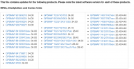
There is no list of the latest software version numbers for equipment.


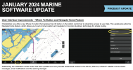
They made a change to get rid of "Info" button and changed it to "Where To" I don't see that.

Screenshot 2024-04-05 at 3.42.11 PM.png
 

SkunkBoat

Well-Known Member
Joined
Oct 12, 2017
Messages
4,509
Reaction score
1,614
Points
113
Location
Manasquan Inlet NJ
Website
www.youtube.com
Model
Express 265
Apparently there is also a software change that allows certain models to now use SD Cards over 32GB
Says mine is compatible?

I JUST bought some 32GB to have around because one of mine with old garmin data took a crap while I was trying to reformat it.
 

Hookup1

GreatGrady Captain
Joined
Oct 16, 2007
Messages
3,035
Reaction score
856
Points
113
Age
70
Location
Cape May, NJ
Model
Islander
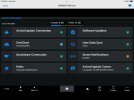
Active Captain bottom bar > Boat Apps > My Marine Devices shows software info. I have System Version 2024.0103.0 waiting to install.

When connected to your plotter via boats wifi updated charts will be uploaded. It's strange how Garmin loads maps particularly the shaded relief. You have. to zoom in with Active Captain > Charts and scroll around. You will see that it's downloading maps. Later when you connect to boat wifi it will upload them to the unit. There is nowhere to see charts loaded or revisions. It's just Garmin magic.

I'm controlling all my Garmin map purchases and renewals using Garmin's web site. I'm not using Active Captain for that.

Since I have active Garmin Navionics Vision+ North and South subscriptions I get all the updates for East and Gulf Coast's. The BUS001L basemap subscription isn't really necessary. If I get my refund from Apple I probably won't re-subscribe.

I have been using 32gb SD cards with my 86xx series chartplotter for a while now. SanDisk and some cheap ones for data transfer. Working fine. Overkill but cheap enough. I have 2 SD card slots on the back side of each of my chart plotters. I also have a external dual slot SD reader that is accessible from the front. A Active Captain card is in the back of one of them and the other three card slots are empty. I have 2 blank SD cards in the external reader so I can save screen shots and backup/restore waypoint sets. This way there is no need to access the back of my units for SD cards.
 

SkunkBoat

Well-Known Member
Joined
Oct 12, 2017
Messages
4,509
Reaction score
1,614
Points
113
Location
Manasquan Inlet NJ
Website
www.youtube.com
Model
Express 265
Active Captain bottom bar > Boat Apps > My Marine Devices shows software info. I have System Version 2024.0103.0 waiting to install.
Ya if you look at this the 20240103 updates your 8600 to v34.00. My 1242 Touch Plus is still at 28.40

Do you now see the "Where to" button?


Screenshot 2024-04-05 at 11.01.51 PM.png

I still don't see where the Map updates are shown. They say with subscription you get "daily" updates whatever that means. How do you know whats different?
I mean, Ive seen new things in Relief Shading by accident but I have no idea when they got there...
 

Hookup1

GreatGrady Captain
Joined
Oct 16, 2007
Messages
3,035
Reaction score
856
Points
113
Age
70
Location
Cape May, NJ
Model
Islander
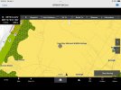
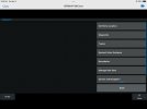
Here's the "Where To" button and the screen behind it.
IMG_0026.jpeg IMG_0027.jpeg

I sometimes see Active Captain updating and validating charts but there is no detail anywhere.
IMG_0029.jpeg
 

Beyond A Wake

Well-Known Member
Joined
Jan 23, 2022
Messages
238
Reaction score
43
Points
28
Age
73
Model
Freedom 335
I guess the daily updates would have to be downloaded daily to your SD card.
I don't have active captain and I don't have Garmin, just plain axiom pro Raymarin........ but same cartography I assume from Navionics (now GArmin owned) My understanding of all the update stuff is that people who upload new data contribute to the mass/crowd collected depth data and that especially is what happens daily. Official updates from authorities I believe are more seldom unless critical. Like bridge info, lighthouse info etc....

I'm not using the updates with any frequency just when I remember or think that I would benefit from potential updated info.
The version info should always be available both for Navionics and for Garmin/Raymarin SW as well.

H
 

Hookup1

GreatGrady Captain
Joined
Oct 16, 2007
Messages
3,035
Reaction score
856
Points
113
Age
70
Location
Cape May, NJ
Model
Islander
There are several types of updates the Active Captain uploads to the Garmin units. First are software updates for the unit. Second are the updates to the charts- navigation, fishing and shaded relief. Also the complete set of charts for example the south East and Gulf are not fully loaded to the unit. You move around the area you are interested in while offline and Active Captain notes these areas and flags then for upload. The third type are Active Captain Community info about Marinas and even bottom detail that can be uploaded. This third type I don’t load.