Garmin software update

SkunkBoat

Well-Known Member
Joined
Oct 12, 2017
Messages
4,509
Reaction score
1,614
Points
113
Location
Manasquan Inlet NJ
Website
www.youtube.com
Model
Express 265
I have my 1242 plus xsv in the house on a battery to play around with it(I bought an extra power cable for it). Going to load/rename waypoints, etc.
I downloaded the latest software on the Active Captain App. Easy peasy! Well, they made a big change to the user interface and menus. Going to have to re-learn some things. They went to a scrolling menu for "Pinned" screens. Good thing I have it inside to play with it!
 

seasick

Well-Known Member
Joined
Aug 19, 2008
Messages
9,531
Reaction score
1,420
Points
113
Location
NYC
I have power supplies and cables for all my MFDs. That allows me to also 'play' at home. Usually each spring, I have to relearn the more common functions since all units have different interfaces and some (Lowrance) units are not as intuitive as others ( Garmin). Granted, they are older models and maybe the newer ones are more user friendly. In addition, I forget a lot of things as I grow older.
 

Hookup1

GreatGrady Captain
Joined
Oct 16, 2007
Messages
3,035
Reaction score
856
Points
113
Age
70
Location
Cape May, NJ
Model
Islander
I put the boat outside my kitchen window. From my island I can acces the boat Wi-Fi and the house Wi-Fi. Still annoyed with Garmin discontinuing. HomePort. I still use it for maintaining separate lists of waypoints that can be merged onto my unit.
 
  • Like
Reactions: blindmullet

SkunkBoat

Well-Known Member
Joined
Oct 12, 2017
Messages
4,509
Reaction score
1,614
Points
113
Location
Manasquan Inlet NJ
Website
www.youtube.com
Model
Express 265
I put the boat outside my kitchen window. From my island I can acces the boat Wi-Fi and the house Wi-Fi. Still annoyed with Garmin discontinuing. HomePort. I still use it for maintaining separate lists of waypoints that can be merged onto my unit.
Do you have the Garmin Navionics+ or the Garmin G3 Vision?
If so, do you find the shaded contours useful? I currently have g3 which does not have shaded relief.

Wondering if I should update my G3 to Vision or get Navionics.
G3 Vision for Boston to Norfolk is $449. Garmin Navionics + US is $199
Their marketing appears to have high def bottom "thru Active Captain in some areas" but I can't see if its good in my area.
Does that mean it requires a web connection to use in the App?
I'm confused.:rolleyes:
 

Ryhlick

GreatGrady Captain
Joined
Jul 15, 2016
Messages
210
Reaction score
70
Points
28
Do you have the Garmin Navionics+ or the Garmin G3 Vision?
If so, do you find the shaded contours useful? I currently have g3 which does not have shaded relief.

Wondering if I should update my G3 to Vision or get Navionics.
G3 Vision for Boston to Norfolk is $449. Garmin Navionics + US is $199
Their marketing appears to have high def bottom "thru Active Captain in some areas" but I can't see if its good in my area.
Does that mean it requires a web connection to use in the App?
I'm confused.:rolleyes:
I bought the G3 vision card for the west coast (Oregon) and it is fantastic. I was using the navionics on my phone before, but having it on the chart plotter is a real bonus for me. It is very accurate as far as showing bottom structure / shading when I have compared it to my charts. What I like is it lets you see the structure you are setting up on with great detail. Buy the card, I do not think you will be disappointed.
 

Hookup1

GreatGrady Captain
Joined
Oct 16, 2007
Messages
3,035
Reaction score
856
Points
113
Age
70
Location
Cape May, NJ
Model
Islander
Do you have the Garmin Navionics+ or the Garmin G3 Vision?
If so, do you find the shaded contours useful? I currently have g3 which does not have shaded relief.

Wondering if I should update my G3 to Vision or get Navionics.
G3 Vision for Boston to Norfolk is $449. Garmin Navionics + US is $199
Their marketing appears to have high def bottom "thru Active Captain in some areas" but I can't see if its good in my area.
Does that mean it requires a web connection to use in the App?
I'm confused.:rolleyes:
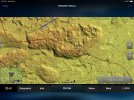
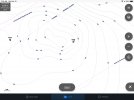
I have the Garmin G3 Vision card for South Florida. This gives me the shaded relies for the Key's. On the reef patches I fish like my 0004 spot it shows more detail. Not sure how this is derived - maybe satellite /aerial photo imagery - but it looks real. We have been fishing our usual reef spots but fine tuning where we drop anchor. This detail disappears along the reef edge. If you are going to get it for NJ see if you can get a look at it first.

Shaded Relief 1.jpeg Shaded Relief 2.jpeg
 

SkunkBoat

Well-Known Member
Joined
Oct 12, 2017
Messages
4,509
Reaction score
1,614
Points
113
Location
Manasquan Inlet NJ
Website
www.youtube.com
Model
Express 265
hehe your pix are tiny.
be careful, they have rules about anchoring on reefs in the keys.

the high def stuff is from towed array side scan sonar and some comptur enhancement to add 'shadow'

I'm guessing that garmin has the same stuff i see on the noaa site because its free goverment stuff.
they dont let you see a high def chart on their website. mybe i'll go to west marine and see if its on something there.
I dunno about paying $449 for vision.
i looked at the navionics they also only let you play with their std chart.
I'm used to the garmin chrts. i dont think i want to go to navionics

since garmin bought navionics i wonder what the future is going to look like


you have a 943 and an 8612? did you do the 2022 update?
 

Hookup1

GreatGrady Captain
Joined
Oct 16, 2007
Messages
3,035
Reaction score
856
Points
113
Age
70
Location
Cape May, NJ
Model
Islander
I did my last update in January. I don't have the time down here and don't want to mess anything up.

West isn't going to have the G3 card. Maybe they can connect you with their Garmin rep or arrange for you to see them at a show.

My guess is Garmin will still keep the Navionics brand since they supply charts for other manufacturers.

Try these...
IMG_0113.jpeg IMG_0116.jpeg
 
  • Like
Reactions: SkunkBoat

SkunkBoat

Well-Known Member
Joined
Oct 12, 2017
Messages
4,509
Reaction score
1,614
Points
113
Location
Manasquan Inlet NJ
Website
www.youtube.com
Model
Express 265
I did my last update in January. I don't have the time down here and don't want to mess anything up.

West isn't going to have the G3 card. Maybe they can connect you with their Garmin rep or arrange for you to see them at a show.

My guess is Garmin will still keep the Navionics brand since they supply charts for other manufacturers.

Try these...
View attachment 24676 View attachment 24677
maybe I'll go to the AC boat show. Garmin usually has a booth.
 

Hookup1

GreatGrady Captain
Joined
Oct 16, 2007
Messages
3,035
Reaction score
856
Points
113
Age
70
Location
Cape May, NJ
Model
Islander
So today I did the latest Garmin software update for my 8612xsv and 943xsv. Active Captain did a good job. Update was for 25.30 to 26.20.

Garmin seems to have gotten the message that the screen height is more important than the screen width. You can now put your data bar on the side (instead of the top) and you can "hide" the bottom bar (you always could). This allows use of the full height of the screen and results in a more "square" screen. Exactly what I want to see further out around me.

I'm back in NJ now and probably won't get to test it more until I get back to FL but it looks promising.

Now I would like the ability to configure font and track sizes to make things easier to read on the water.
 
Last edited:

Sauza45

Well-Known Member
Joined
Dec 8, 2021
Messages
101
Reaction score
24
Points
18
Location
Sarasota
Model
Canyon 271
I have the Garmin 8616 and the new update is up to 26.20 now