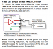
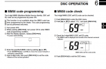
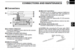
Able to input MMSI #. Hooked up ICOM red to GARMIN blue, and ICOM white to GARMIN brown. No location/GPS data between the two.
Anything i'm missing ?
Does the red wire on the M422 have a braided shield? If so, connect it to the Black ground wire of the M422.
I'm going to ignore the white wire and inputs to the Garmin because you are probably never going to make/review DSC calls using the Garmin...
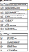
Your Garmin may need to be configured to output GPS data sentences on port
Look in your manual for similar to this...
Configuring NMEA 0183 Output Sentences
You can enable and disable NMEA 0183 output sentences.
Select
Settings >
Communications >
NMEA 0183 Setup >
Output Sentences.
Select an option.
Select one or more NMEA 0183 output sentences, and select
Back.
Repeat steps 2 and 3 to enable or disable additional output sentences.
 Setting the Communication Format for Each NMEA 0183 Port
You can configure the communication format for each internal NMEA 0183 port when connecting your chartplotter to external NMEA 0183 devices, a computer, or other Garmin devices.
Select
Settings >
Communications >
NMEA 0183 Setup >
Port Types.
Select an input or output port.
Select a format:
To support the input or output of standard NMEA 0183 data, DSC, and sonar NMEA input support for the DPT, MTW, and VHW sentences, select
NMEA Std..
To support the input or output of standard NMEA 0183 data for most AIS receivers, select
NMEA High Speed.
To support the input or output of Garmin proprietary data for interfacing with Garmin software, select
Garmin
Repeat steps 2–3 to configure additional input or output ports.


