You are using an out of date browser. It may not display this or other websites correctly.
You should upgrade or use an alternative browser.
You should upgrade or use an alternative browser.
Sirius Marine Weather
- Thread starter Meanwhile
- Start date
Hookup1
GreatGrady Captain
- Joined
- Oct 16, 2007
- Messages
- 3,186
- Reaction score
- 908
- Points
- 113
- Age
- 70
- Location
- Cape May, NJ
- Model
- Islander
A lot depends on what you need. Are you fishing? Do you need weather alerts while you car out? Lightning reports?
Sirius weather is really the only game in town anymore. We us a service called ROFFS on the east coast for tournament fishing. I don't think they offer coverage on the West coast.
So let's start with your needs and expectations.
Sirius weather is really the only game in town anymore. We us a service called ROFFS on the east coast for tournament fishing. I don't think they offer coverage on the West coast.
So let's start with your needs and expectations.
Fishing for albacore tuna out of Oregon. I use RipCharts now and you can download the charts pre trip but it is not available on the ocean, unless very close. I need up to 60 miles coverage.
Hookup1, do you have Sirius Weather?
Hookup1, do you have Sirius Weather?
- Joined
- Mar 1, 2006
- Messages
- 3,069
- Reaction score
- 1,378
- Points
- 113
- Location
- Berea, KY/Cross, SC
- Model
- Seafarer
I have both Sirius weather and radar. I've had Sirius for quite awhile. I use it for weather alerts and wind direction mainly. I just installed the radar this year so still in learning curve with it. I can only overlay my chart with one or the other right now. I haven't played with MFD enough to see if I can go to a 3 way split window to see if I can overlay both Sirius and weather on different screens.
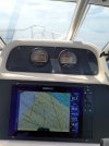
Here's a Pic from my Keys trip and you can see the wind barbs on the MFD. Almost running with the wind on our way back in.

Here's a Pic from my Keys trip and you can see the wind barbs on the MFD. Almost running with the wind on our way back in.

Hookup1
GreatGrady Captain
- Joined
- Oct 16, 2007
- Messages
- 3,186
- Reaction score
- 908
- Points
- 113
- Age
- 70
- Location
- Cape May, NJ
- Model
- Islander
We use Sirius weather for tournament fishing in the NE Canyons. Eddys move in and around slowly. ROFFS SST service helps us understand the water movement in detail from dad-to-day. Sirius helps us ground truth ROFFS (delivered late the night before). Sirius shows you real time the water temps but not the movements.
In the Florida keys during the winter I have not tried Sirius. Not installed on my GW Islander. I use ROFFS occasionally. The water there turns over quickly sometimes within a few hours. Sirius would be perfect but people fishing here have not had good things to say about it. I will probably install it this winter and try it.
Not sure what your situation is on the West Coast. I know there is a cold water current coming down the beach.
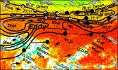
I couldn't find an old ROFFS report for Northern Canyons. Here is a Florida Keys report from earlier this year.
FISHERIES OCEANOGRAPHIC ANALYSIS FOR THE KEYLARGO TO SUGARLOAF KEY ANALYSIS AREA(LAT./LONG.) UPDATED ON THURSDAY 10 FEBRUARY 2022FOR THURSDAY P.M. AND FRIDAY FISHING ONLY
Based on a multiple factor oceanographic analysis, the indicated areas (hot spot dots) on the analysis mark the areas where bait concentrations are expected and where fishing action is expected to be better compared with other areas. Numbers inside of the hot spot dots indicate the number of consecutive days that we have seen favorable oceanographic conditions in that location. These areas are not based on dock rumors or hearsay fishing reports, they are based on oceanographic knowledge and expertise. You should start fishing where you recognize other signs of good fishing conditions near these marked areas (ie. rips/slicks, weed lines, birds, etc). It is very important to use your sea surface temperature (SST) gauge to locate the boundaries of the water masses, which are outlined in black. PLEASE REMEMBER, rather than trying to find water masses based on the absolute temperature values shown on the map, search for the relative change in SST where the water mass boundaries occur. Arrows indicate the main current direction. 1 fathom = approximately 6 feet. Afternoon SST is likely to be 1.0°F or more WARMER than indicated by the morning SST calibration on this analysis. NUMBERS IN PARENTHESES AFTER LOCATIONS ARE NUMBER OF DAYS THAT SPOT HAS BEEN FAVORABLE. We now provide cloud-free SST and ocean color/chlorophyll data from our new partner Fathom Science™ for at 6am forecast for the next day. For more information please visit https://www.roffs.com/faqs/.
We were able to provide this analysis using a combination of infrared SST° and ocean color/chlorophyll imagery from this afternoon to increase your chances of tuna, dolphin, wahoo and billfish. Overall, we’ve observed three eddies influencing the area. Starting to the east, we’ve observed the tail end of an eddy filament extending along Key Largo to Lower Matecumbe. As a result, we’ve observed a favorable green to blue 76-78°F edge along 20-30 fathoms with the exception of a small offshore flow centered over Conch Reef. By tomorrow, we expect the tail end of this filament will pull north to Tavernier, creating favorableconditions extending north to the Elbow. Looking west, we’ve observed cooler 77°F water dominate the offshore area along 30-100 fathoms. South of this cooler blue water, we’ve observed the Gulf Stream with two eddies centered over the Islamorada Humps and east of the Ups and Downs. The eddy over theHumps is relatively small, resulting in blue water rotating inshore into 120 fathoms. By tomorrow, we expectthis eddy will be centered off of Key Largo. The second eddy, is very large, circulating a filament of 78-80°F water west along 100-180 fathoms. By tomorrow, we expect this eddy will be centered off of Fiesta Key, with its filament extending west to Bahia Honda. We have included an ocean color/chlorophyll composite image from this afternoon so you can get a sense of where the bluer and greener water is located (email only,white=clouds).
With this in mind, conditions suggest your best chance for sailfish as well as tuna, dolphin, and wahoo will occur along the green to blue 76-77°F edge extending over the wrecks and reefs off of Islamorada such as Alligator Reef to Marathon near 80°37’W & 24°53’N, Tennessee Reef near 80°45’W & 24°45’N, 80°51’W & 24°43’N, and 80°00’W & 24°53’N (2). If this edge isn’t as productive as you’d like, conditions suggest tuna, dolphin and billfish along the 77-80°F eddy filament edges we predict will extend along 75-100 fathoms near 80°30’W & 24°49’N, 80°40’W & 24°44’N (2), 80°49’W & 24°39’N (2), and 80°57’W & 24°35’N (3).
Looking west, we predict similarly favorable green to blue edges extending along 30 fathoms off of Marathon to Sugarloaf near 81°06’W & 24°37’N (2) to 81°17’W & 24°34’N (3), and 81°30’W & 24°30’N (3). Offshore, the eddy filament will begin pulling offshore as it exends west of Marathon along 100-130 fathoms over the Ups and Downs near 81°07’W & 24°32’N (3) to 81°14’W & 24°27’N.
Looking off of Islamorada and east, we predict an offshore flow of cooler greener water will be centered off of Islamorada indicating scattered action. To the east, we predict favorable green to blue 76-78°F edges along 30 fathoms from Conch Reef to French Reef near 80°28’W & 24°52’N to 80°20’W & 25°04’N (2). Keep in mind however, this edge will continue pushing east with the Gulf Stream throughout the day. Looking offshore in the area conditions indicate your best chance of marlin as well as an additional chance of tuna and dolphin along the 78-80°F edge extending east over the Humps near 80°27’W & 24°49’N to 80°14’W &24°57’N.


