Garmin Navionics+ on GPSMAP chartplotters.

SkunkBoat

Well-Known Member
Joined
Oct 12, 2017
Messages
4,524
Reaction score
1,620
Points
113
Location
Manasquan Inlet NJ
Website
www.youtube.com
Model
Express 265
Plugged in the chip but you have to "register" it on A.C. to get the extras. They have to downloaad to the phone then download to the Garmin.
 

Hookup1

GreatGrady Captain
Joined
Oct 16, 2007
Messages
3,042
Reaction score
864
Points
113
Age
70
Location
Cape May, NJ
Model
Islander
So I got the SD card in the Garmin, registered on Active captain, downloaded something....there is a lot of back & forth between Wifi to internet on phone to get stuff in Active captain, then Wifi to Garmin to download from Active captain...

So I see the new stuff on my phone in active captian. After some downloading, I have the extras like Raster Charts, Shaded relief, etc.

On the Garmin the new chart doesnt look much different than g3 but now has Depth shading and Shallow shading in the Navionics style I think. It has Photos.
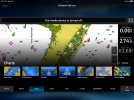
I can't find Shaded Relief on the Garmin. That is the main reason I wanted the Vision+. Its on Active Captain. Maybe i just need to have the WiFi connected longer.

The Garmin "Fishing Chart" has 1 ft depth lines but you only see them when you zoom in. If you look at your Navionics screenshots vs Active Captain you can see that.

Edit: There are "Chart Settings" in Active Captain. Changing "Chart Size" to small will display the 1 ft lines on Active captain. There are choices for how to display Waypoints.

My Garmin is acting different somehow. Must be part of an update. not quite sure what it is.
Basemaps arrived a day early. Plugged the chip in. Opened Active Captain, switched to boat wifi, internet and back. Pulled chip. Everything looks fine.

This chip does not contain Vision+ so no shaded relief for me (yet). Shaded relief will show up on your unit as a type of chart. Go into Active Captain>Settings>Chart Download Settings. Make sure Shaded Relief is checked.

I did get 1' contours in shallower water. They kept the Garmin style waypoints with names that can be displayed. I see more detail on the artificial reefs.

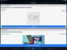
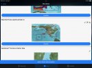
Go to Active Captain app on phone or tablet. Select center bottom icon - Charts. Select 3 dash menu on upper right and go to MyCharts. You should see your new charts in there. Exit and go back in. Select Download charts - you should see all the charts you have access to. Select an area for North Jersey and install charts.

See if things start to look right.
 

Diad

Well-Known Member
Joined
Nov 9, 2022
Messages
180
Reaction score
52
Points
28
Model
Express 265
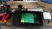
Just got a couple of the 1243XSV’s with Navionics. Coming from Furuno I’m excited to play with this stuff. Need the panels from New Wire to come in. If anyone has seen my battery switch thread, I have plenty of power! Just can’t turn it off
 

Attachments

  • 976A528A-382C-4832-A436-D1E683650249.jpeg
    976A528A-382C-4832-A436-D1E683650249.jpeg
    1.7 MB · Views: 3
  • Love
Reactions: SkunkBoat

SkunkBoat

Well-Known Member
Joined
Oct 12, 2017
Messages
4,524
Reaction score
1,620
Points
113
Location
Manasquan Inlet NJ
Website
www.youtube.com
Model
Express 265
Ok.. things are starting to show up. Got shaded relief in the menu now. Maps look more like Navionics.
 
Last edited:

SkunkBoat

Well-Known Member
Joined
Oct 12, 2017
Messages
4,524
Reaction score
1,620
Points
113
Location
Manasquan Inlet NJ
Website
www.youtube.com
Model
Express 265
Just got a couple of the 1243XSV’s with Navionics. Coming from Furuno I’m excited to play with this stuff. Need the panels from New Wire to come in. If anyone has seen my battery switch thread, I have plenty of power! Just can’t turn it off
Twin 1243s are gonna be sweet on that 265:D:D
 
  • Like
Reactions: Diad

Hookup1

GreatGrady Captain
Joined
Oct 16, 2007
Messages
3,042
Reaction score
864
Points
113
Age
70
Location
Cape May, NJ
Model
Islander
I’m getting a few artifacts from the g3 charts. Although I formatted theActive Captain card and removed my Florida g3 Vision card it still shows shaded relief as an option and doesn’t display them (which is ok). I would also like to get the g3 basemaps out and the Navionics installed in the unit (currently installed on Active Captain card).

I‘ll call Garmin Monday.
 

wspitler

GreatGrady Captain
Joined
May 16, 2011
Messages
1,368
Reaction score
320
Points
83
Location
Inglis, FL
Model
Express 330
Remember guys, with the exception of sonar data generated and shared by users through the Active Captain App, the sounding data and detail is not new stuff. I suspect it is computer generated based on hydrographic surveys and sometimes near ancient sounding data and therefore not real. Most coastal and offshore soundings were done years ago and many are simply spot soundings. When was the last time you saw a government survey vessel collecting depth data in your area. One foot depth contours for most areas are simply not realistic. Shading and detail is very nice, but often it is not actual recorded sounding data. It is likely computer interpolated and probably pretty close to real. The charts are not updated frequently with regard to NOTAM (notice to mariner) publications. For instance it will not have changes to aids to navigation that are recent (maybe years old) or recent shifts in channels. Bottom line for me, is for coastal stuff in shallow, Google earth is pretty informative, but I won't pay a lot for revisions and fancy shading. Of course I'm an old timer that used DR for years and then got LORAN which I thought was amazing! Little did I know. All the additional detail and bells and whistles is nice, but as someone once said "that gun don't shoot that straight!"
 

SkunkBoat

Well-Known Member
Joined
Oct 12, 2017
Messages
4,524
Reaction score
1,620
Points
113
Location
Manasquan Inlet NJ
Website
www.youtube.com
Model
Express 265
Remember guys, with the exception of sonar data generated and shared by users through the Active Captain App, the sounding data and detail is not new stuff. I suspect it is computer generated based on hydrographic surveys and sometimes near ancient sounding data and therefore not real. Most coastal and offshore soundings were done years ago and many are simply spot soundings. When was the last time you saw a government survey vessel collecting depth data in your area. One foot depth contours for most areas are simply not realistic. Shading and detail is very nice, but often it is not actual recorded sounding data. It is likely computer interpolated and probably pretty close to real. The charts are not updated frequently with regard to NOTAM (notice to mariner) publications. For instance it will not have changes to aids to navigation that are recent (maybe years old) or recent shifts in channels. Bottom line for me, is for coastal stuff in shallow, Google earth is pretty informative, but I won't pay a lot for revisions and fancy shading. Of course I'm an old timer that used DR for years and then got LORAN which I thought was amazing! Little did I know. All the additional detail and bells and whistles is nice, but as someone once said "that gun don't shoot that straight!"
My first sonar was an Eagle paper graph...X-15

I think I mentioned that back a ways in this thread that the shading is mostly based on old stuff and may be averaging and guestimating.

The jersey coast has some really detailed NOAA bathymetry done and that is what is in certain parts of these Vision relief shading charts. I was able to find it FREE on NOAA Bathymetry site but that doesn't put it on my chartplotter with my waypoints superimposed over it. So I bit the bullet and I am pleased.

I am going to post some screenshots of my waypoints and last year's tracks over top of Shaded relief and 1 ft contours.
They line up perfectly.
I have noticed already that the hi res soundings and the 1 ft contours were done at MIXED times, probably over several years. Some rockpiles don't have 1ft countours and some 1 ft contours of rockpiles don't show in shaded relief. There are some new rockpiles that I know of that are not shown in these charts...

I think the shaded relief is going to be very useful in "seeing" interesting new places to try, that would never be a thought otherwise.
That could be structure for bottom fishing or a ridge for trolling tuna
 

Hookup1

GreatGrady Captain
Joined
Oct 16, 2007
Messages
3,042
Reaction score
864
Points
113
Age
70
Location
Cape May, NJ
Model
Islander
Yes and no. I have always told my friends that charts outside “the path most traveled” is dangerous. They are concerns about large vessel navigation not someone cutting across a flat.More importantly is the Nav AIDS. In your local area you are probably aware of the changes. But if you are cruising updates are more important.
 

Hookup1

GreatGrady Captain
Joined
Oct 16, 2007
Messages
3,042
Reaction score
864
Points
113
Age
70
Location
Cape May, NJ
Model
Islander
I have been matching up places in the Keys we fished in the past with shaded relief. We had no idea why the spots were productive. Pretty obvious now!
 
  • Like
Reactions: SkunkBoat

SkunkBoat

Well-Known Member
Joined
Oct 12, 2017
Messages
4,524
Reaction score
1,620
Points
113
Location
Manasquan Inlet NJ
Website
www.youtube.com
Model
Express 265
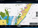
Look this over. You’ll see they line up with my real world waypoints. sometimes the contours lineup with the rock piles sometimes they don’t so the soundings were done on different dates or years.

046EF90B-2BE8-4995-BD41-E635F8205D14.jpeg
 

Hookup1

GreatGrady Captain
Joined
Oct 16, 2007
Messages
3,042
Reaction score
864
Points
113
Age
70
Location
Cape May, NJ
Model
Islander
I always thought these wrecks were pretty cool the way they lined them up. The shaded relief makes them pop!
 

Hookup1

GreatGrady Captain
Joined
Oct 16, 2007
Messages
3,042
Reaction score
864
Points
113
Age
70
Location
Cape May, NJ
Model
Islander
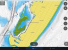
This basemap installation just doesn't look right. New Garmin Navionics+ BUS001L installed as a supplemental map. It's supposed to replace built-in.
The Garmin Bluechart g3 show up as Built-in map. I want to eliminate the Bluechart g3 maps altogether.

IMG_0003.jpeg

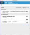
Active Captain > MyCharts show the VUS010R Bluechart. They have been removed from my unit (formatted Active Captain SD card) and card is not in the unit. This registration is retained in Garmin's cloud and I have not found a way to remove/delete it. I would prefer to eliminate the Bluchart g3 and have the Garmin Navionics+ as the built-in (as advertised!).

IMG_0004.jpeg IMG_0005.jpeg

Why doe it matter? On the unit I have option for shaded relief maps. They are not installed and don't display on the unit. Something is confused. Active Captain does not show shaded relief which is correct.

IMG_0006.jpeg IMG_0007.jpeg
 
Last edited:

Hookup1

GreatGrady Captain
Joined
Oct 16, 2007
Messages
3,042
Reaction score
864
Points
113
Age
70
Location
Cape May, NJ
Model
Islander
This might explain some of the flakey views.

In Active Captain > Menu > Delete Charts > Delete All. This will remove all charts downloaded to AC and your unit. Maps remain in the cloud.

Next in AC Charts > Download Charts > (move to and select an area, then chart type) > Download. AC will install the area in AC and your unit.

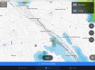
In the screenshot below you can see the upper boundary of the Garmin Navionics+ on the unit. The second screenshot is AC - initially partial map but it went into download mode and filled the rest in with Garmin Navionics+. No boundary.

IMG_0008.jpeg IMG_0009.jpeg

I'm giving up on installing the new BUS001L basemaps as built-in for now. Not sure what it buys me and Garmin removed the built-in map installer from the menus.
 

SkunkBoat

Well-Known Member
Joined
Oct 12, 2017
Messages
4,524
Reaction score
1,620
Points
113
Location
Manasquan Inlet NJ
Website
www.youtube.com
Model
Express 265
I was playing with Fishing Map Presets. I am a bit confused. After you choose a preset, how do you know which one you are in? When you turn On, what preset are you in? The last choice? How do you know?
I was entering Depth shading for the 30 to 80 ft in 10 ft increments. Wanted to see if its useful for inshore ..fluking, stripers... tried to save it as a "Coastal" preset.
First time it did it somehow it didn't save. I think I figured it out.

In theory, you can have a preset with shading (and other settings) for inshore depths and also have a preset with shading using the same colors for the canyon depths.

On thing I did was make all of the presets North UP.
 

Hookup1

GreatGrady Captain
Joined
Oct 16, 2007
Messages
3,042
Reaction score
864
Points
113
Age
70
Location
Cape May, NJ
Model
Islander
I'll have to try the depth shading. Up North it would be handy to follow a snaking edge - maybe the 50 line or 100 line.

Sailfishing in FL I mainly use the sounder and fish the edge of the reef (about 80 feet) in/out to 200 feet. Contours somewhat straight.

So I couldn't just leave the idea of replacing the built-in maps alone. I had one more idea to try this morning. Using Garmin Express I built a SD card with the BUS001L built-in map subscription. I installed the card in the unit and was prompted to Update Built-in Maps. It took 2 hours to update but it worked. Now my unit only has the Garmin Navionics+ Built-in maps on it. Had to repeat the install on the second unit.

IMG_0010.jpeg
 
  • Like
Reactions: SkunkBoat

Hookup1

GreatGrady Captain
Joined
Oct 16, 2007
Messages
3,042
Reaction score
864
Points
113
Age
70
Location
Cape May, NJ
Model
Islander
Anyone who wants to replace built-in g3 base maps with New Garmin Navionics+ base maps follow this. Worked for me.

Pull the Active Captain card out. Build the SD card with Garmin Express. You need the BUS001L. It was on sale for $100 direct from Garmin but sale over and back to $150. I installed it with Active Captain first but it wasn’t the way I wanted it but it registered the subscription. If you don’t see it in Garmin Express you need to somehow register the subscription. Select BUS001L subscription and create the card. Best to do it on a hardwired PC or laptop for speed. It will take an hour or two. Just let it run.

Screen Shot 2023-04-03 at 8.19.58 PM.png

Run the install without Active Captain. When done pull the update SD card. Reboot and check software tab.

I reformatted my Active Captain card on my PC after updating both units then reinstalled it. This will give you a clean install with no map artifacts. Then run Active Captain setup, reformat again and sync.


From The Hull Truth Electronics Forum:
Todd Driscoll: Yes, the built-in mapping updates will completely transfer to the MFD, but only if the MFD has enough internal memory. This will vary some from one user to another. Simply put, most MFDs produced since 2019 will have enough memory to permanently transfer a built-in update, but there will be individual exceptions to this. When there isn't enough internal memory, the built-in update must be read from the SD card.
__________________
Garmin Pro Team
 
Last edited: